Water Activities
Canoeing and kayaking opportunities abound. Paddling on the Flowage is a flat-water experience. A voluntary quiet area has been established on approximately the eastern 1/5 of the Flowage. The quiet area boundaries run from the narrows near Blair Lake upstream to the property boundary which is near the confluence of the Bear and Manitowish Rivers. The purpose of this designation is to promote an atmosphere of quiet solitude for those seeking a “wilderness” type experience.
To experience more of a thrill while paddling, try the Flambeau, Turtle, Manitowish or Bear Rivers which have a current and whitewater adventure. Area outfitters provide services for paddling, rafting and tubing.
There are an abundance of sandy beaches available for swimming and relaxing on many of the 195 islands scattered throughout this pristine body of water to make your own personal paradise oasis.
There are six boat landings in the Turtle-Flambeau Scenic Waters Area providing boat and canoe launch facilities on the Turtle-Flambeau Flowage.
Fishing
The Flowage provides the ultimate northwoods fishing experience. It supports a diversified fishery including walleye, muskellunge, smallmouth and largemouth bass, crappie, perch and bluegill.
The Flowage is best known for its superb walleye fishery. Walleye are by far the most abundant gamefish and provide the majority of sport fish harvest. The abundance of catchable size walleye is outstanding.
Crappie have proven to provide some exceptional panfishing during the early summer, fall and through the ice. Jumbo perch and big bluegills provide action year’ round.
Muskies provide outstanding trophy angling. In the past muskies in excess of 50 pounds have been caught. Annual stocking is used to supplement the limited natural reproduction.
Smallmouth bass provide quality fishing throughout the year. “Smallies” in the flowage are exceptionally heavy fish for their length and are commonly referred to as “footballs”. This is why it has become a trophy smallmouth fishery.
Hundreds of fish cribs have been installed through-out the Turtle Flambeau Flowage in 10-15 feet of water. The cribs provide cover for the smaller fish to hide and grow. They also provide excellent structure for larger fish to congregate.
Lake of the Falls County Park offers the largest amount of shore fishing opportunities on the Turtle Flambeau Flowage. On West Popko’s Circle, just south of the county park, there is a dike that shore anglers frequent. Also on West Popko’s Circle, where Trude Lake empties into the flowage, there is a culvert and shore fishing area. Anglers may also go to the boat landings and work the shoreline from there.
There are six boat landings in the Turtle Flambeau Scenic Waters Area providing boat and canoe launch facilities on the Turtle Flambeau Flowage.
Ice fishing on the Flowage is a favorite pastime. Winter brings about another dimension of fishing opportunities. Ice anglers will find plenty of action between tip-up fishing for walleye and bass to jig pole fishing for slab crappies, jumbo perch and big bluegills. Check out our events page to find information about ice fishing tournaments. Caution should always be used on the ice so check with the local bait shops and resorts about current ice conditions before venturing out. You’ll find that this is where the locals fish for fun and success!
Hunting
The Turtle Flambeau Scenic Waters Area encompasses approximately 35,000 acres of public land. The diverse topography, vegetative cover and water resources of the Turtle-Flambeau Scenic Waters Area offer a wide variety of hunting and trapping opportunities. Deer, bear, ruffed grouse, woodcock, turkey, snowshoe hare, raccoon, coyote, bobcat, red fox, mink, beaver, otter, fisher, muskrat, and a variety of waterfowl call the area home.
The property includes two special wildlife management units.
The Deadhorse Ruffed Grouse Management Demonstration Area is intensively managed in cooperation with the Ruffed Grouse Society to enhance habitat for ruffed grouse. The emphasis is to provide a variety of habitat types of various age classes. Managing for ruffed grouse entails maintaining a relatively young, highly productive forest as well as encouraging mast (acorns) and berry crops.
The Little Turtle Waterfowl Management Area encompasses the Little Turtle Flowage where maintaining breeding and nesting habitat for waterfowl is emphasized. The open grasslands and wetlands help protect nesting waterfowl from predators.
There are twenty-four miles of designated hunter walking trails at the following four locations. Trails are mowed approximately once every two years to maintain the grass and clover for wildlife and to provide hunter access.
Big Island Trail
This trail begins at the bridge to Big Island. From County Highway FF go south on Popko Circle West approximately 3.6 miles and turn right on a woods road heading west towards Big Island. There is a grass parking area for 2 – 3 vehicles about 100 yards before the bridge. There are 8.8 miles of trail on the Island. Big Island Trail Map [PDF 132KB]
Deadhorse Trail
The Deadhorse Trail is located in a special management unit dedicated to intensive management for ruffed grouse. Interpretive signs explaining ruffed grouse management techniques installed at various points on this 4.6-mile trail. Access is off Popko Circle West, approximately 2.0 miles south of County Highway FF. Deadhorse Trail Map [PDF 136KB]
Little Turtle Trail
There are 5.2 miles of mowed trail in the Little Turtle Waterfowl Management Area. To access the trail take Popko Circle East south from County Highway FF approximately 1.1 miles to Joe’s Shack Road. At the end of Joe’s Shack Road turn right to the trail head parking area on the north edge of the Little Turtle Flowage. NOTE: Between the dates of December 15 and April 15 this hunter walking trail is designated part of the MECCA Cross Country Ski Trail. You may not walk or hike on the groomed portion of this trail any time the ground is snow covered between these dates. Little Turtle Trail Map [PDF 167KB]
Wilson Hills Trail
There are 5.5 miles of maintained trail in two segments between Wilson Lake and the Bonies Mound area of the Turtle-Flambeau Flowage. To access the trails from County Highway FF go south on Popko Circle East approximately 3.6 miles to Wilson Lake Road East. Take Wilson Lake Road East 1.1 miles to a woods road heading east. There are several access points along this woods road. Wilson Hills Trail Map [PDF 133KB]
Iron County Forest
The entire Iron County Forest’s 174,317 acres is open to hunting, fishing and trapping. The vast forest is great for hunting numerous large and small game species. Deer stands are allowed on the Iron County Forest if the Deer Stand Rules are followed. In 2009 the Ruffed Grouse Society provided the Iron County Forestry Department with a grant for developing a ruffed grouse and woodcock management area. Contact the department for a map 715-561-2697.
Mercer Target Range
There is a public range open for gun, trap and archery located 5 miles south of Mercer on Range Road off of Hwy 51. The range is maintained by the Northwoods Wildlife and Wetlands Club. The range is open April through November. Donations are accepted and appreciated and are used to help offset expenses.
Hunting Regulations/Rules
All general hunting and trapping regulations apply within the Turtle-Flambeau Scenic Waters Area, but you should take special note of the following regulations before hunting or trapping on this or other state properties.
The Turtle-Flambeau Scenic Waters Area is located in Deer Management Unit 29A, Bear Zone A, Fisher Zone B, Turkey Zone 7 and the Northern Zones for Otter and Waterfowl.
Other Considerations
Many areas of private land lie scattered within the Turtle-Flambeau Scenic Waters Area. Care should be taken to stay on state-owned land and not trespass on adjacent lands without the permission of the landowner. Maps showing the location of public and private land within the Turtle-Flambeau Scenic Waters Area are available at the Mercer Ranger Station and also in map boxes located at a number of boat access sites and trail heads throughout the property.
Most trail access points are gated. Please do not park in front of gates. Access to these gated trails is needed for emergency rescue activities, fire suppression, and forest management operations.
Because the Turtle-Flambeau Scenic Waters Area is used by many other recreationists, hunters should be especially aware of gun safety and his/her conduct while hunting. Hunting near any trail while it is being used by hikers, bikers, and skiers is discouraged. The most heavily used trails are the MECCA Ski Trail and the Hidden Rivers Nature Trail.
ATVing & UTVing
The Turtle Flambeau Flowage is located on the southern end of the largest ATV/UTV trail system in Wisconsin. Approximately 250 miles of trails take you deep into the heart of Iron County. Along these scenic routes and trails you will find direct access to businesses offering food, beverages, gas and lodging. Contact the Mercer Area Chamber of Commerce for a printed map 715-476-2389.
During the winter season ATV/UTV riders are welcome on most Iron County Snowmobile trails. Any snowmobile trail posted with both ATV/UTV and snowmobile signs are open to ATV/UTV riders as long as the average daily temperature is less than 30 degrees. ATVs/UTVs have the potential to do much greater damage to the trails during warm conditions. ATVs/UTVs are welcome to ride on the ice, however, before venturing out make sure that conditions are safe and you know where you are going. Some areas are hazardous throughout the winter because of currents under the ice. In addition, fluctuating water levels can create uneven ice conditions.
Iron County trails are closed for the spring breakup period to protect the trail base from major damage. During this time trail maintenance occurs.
Dirt bikes and motorcycles are NOT permitted on the trails.
ATV Rentals:
Eagle All Sports
32 Wisconsin Ave.
Hurley, WI 54534
715-561-2593
Snowmobiling
The Turtle Flambeau Flowage is located in the Town of Mercer in south eastern Iron County; the “Snow Capital of Wisconsin” deemed so because it receives an average snowfall of over 200 inches of snow each year. Iron County has over 500 miles of scenic trails winding through forests and across frozen lakes that are groomed by three dedicated clubs. With the most reliable snow in the Midwest, plus quick access to additional miles of trail in adjoining counties and Michigan’s UP, the Flowage is the ultimate destination for both families and the more serious snowmobile rider. You’ll find trailside accommodations, pit stops with food and beverage and other services staffed by friendly and knowledgeable local hosts. There are also 175,000 acres available for off-trail Boondocking, where at your own risk, you may ride on County Forest logging roads and skid trails that are not gated, signed or bermed. Snowmobiles are welcome to ride on the ice, however, before venturing out make sure that conditions are safe and you know where you are going. In addition, fluctuating water levels can create uneven ice conditions.
Snowmobile Rentals:
SS SPORT STORE
5168N Hwy 51
PO Box 346
Mercer, WI 54547
715-476-2468
Silent Sports
Silent sports enthusiasts visit the Turtle Flambeau Flowage region seeking a sense of adventure. There are 5 non-motorized trails to choose from in the Turtle Flambeau Flowage Scenic Waters Area. Close by are the MECCA Trails in Mercer, the Pines and Mines Trail System in Iron County and the Ottawa National Forest and many more miles of logging roads and public lands in Iron County to explore. Whether you enjoy hiking, mountain or tour biking, cross-country skiing, snowshoeing or skijoring, you are sure to find a trail or road route to suit your needs. Some woods trails are also designated as hunter walking trails. For your safety trail users should be aware of current hunting seasons. During the 9-day rifle deer hunting season in November silent sports enthusiasts should not venture out on the trails or in the woods.
Turtle Flambeau Flowage Scenic Waters Area
The Turtle Flambeau Scenic Waters Area offers 5 trails, Big Island Trail, Deadhorse Trail, Hidden Rivers Nature Trail, Little Turtle Trail and the Wilson Hills Trail.
Big Island Trail – Trail uses: hiking, biking, snowshoeing, back-country cross-country skiing (not groomed), hunting
This trail begins at the bridge to Big Island. From County Highway FF go south on Popko Circle West approximately 3.6 miles and turn right on a woods road heading west towards Big Island. There is a grass parking area for 2 – 3 vehicles about 100 yards before the bridge. There are 8.8 miles of trail on the Island. The trail is mowed every 3-5 years.
Deadhorse Trail – Trail uses: hiking, biking, snowshoeing, back-country cross-country skiing (not groomed), hunting
This is a 4.6 mile trail. Access is off Popko Circle West, approximately 2.0 miles south of County Highway FF. The Deadhorse Trail is located in a special management unit dedicated to intensive management for ruffed grouse with seven interpretive signs. The signs describe specific management practices and their benefits to grouse. All of the management practices can be applied by private landowners with as little as ten acres. The trail is mowed every 3-5 years.
Hidden Rivers Nature Trail –Trail uses: hiking, wheelchair friendly, snowshoeing
This 2 mile trail has a gravel base. The trailhead is located at the upper parking lot for Fisherman’s Landing. From County Highway FF go south on Popkos Circle Westapproximately 4.5 miles to Fisherman’s Landing Road. There are interpretive signs along the trail explaining the origin of the Flowage and some history as well as some of the management for the property as a whole. Although not groomed, is a great place to enjoy winter scenery and wildlife on skis or snowshoes.
Little Turtle Trail – Trail uses: hiking, biking, cross-country skiing (groomed December – April 15 provided there is ample snow cover), hunting
There are 5.2 miles of mowed trail in the Little Turtle Waterfowl Management Area. To access the trail take Popko Circle East south from County Highway FF approximately 1.1 miles to Joe’s Shack Road. At the end of Joe’s Shack Road turn right to the trail head parking area on the north edge of the Little Turtle Flowage. Bird watching is very popular here because it is the only open prairie in Iron County, so many grassland birds can be seen here and not in other parts of the county. Also, the wetlands provide unique bird watching opportunities as the entire area is visible from a ridge that runs along the edge of the wetland. Note: Between the dates of December 15 and April 15 this hunter walking trail is designated part of the MECCA Cross Country Ski Trail. You may not walk or hike on the groomed portion of this trail anytime the ground is snow covered between these dates.
Wilson Hills Trail – Trail uses: hiking, biking, snowshoeing, back-country cross-country skiing (not groomed), hunting
There are 5.5 miles of maintained trail in two segments between Wilson Lake and the Bonies Mound area of the Turtle-Flambeau Flowage. To access the trails from County Highway FF go south on Popko Circle East approximately 3.6 miles to Wilson Lake Road East. Take Wilson Lake Road East 1.1 miles to a woods road heading east. There are several access points along this woods road. The trail is mowed every 3-5 years.
MECCA Trails, Mercer, WI – Trail uses: Hiking, Biking, Cross-Country Skiing, Snowshoeing, Skijoring
Located in the town of Mercer, there are approximately 18 Km of trails groomed for classic and/or skate skiing. Winter trails are groomed as conditions allow. Snowshoeing, winter hiking and dogs are allowed only on the untracked portions of the trails. A heated log cabin at the Cabin Trailhead offers a changing room, sitting area, and wood stove. There is a portable toilet at this trailhead and at the Little Turtle Trailhead. A warming shack sits at the midway point of the trail along the Little Turtle River.
The MECCA trails are also open for hiking and mountain biking in the spring, summer, and autumn. The trails are a little wider than what most mountain bikers would consider single track. However, they are not wide enough to ride side by side. There are some single track mountain bike trails off of the main MECCA trail that are signed, but they are not maintained on a regular basis.
To get to Cabin Trailhead from downtown Mercer, take US Highway 51 south to Beachway Drive. Then take Beachway Drive south to Mercer Lake Circle. Then go to Fierick Road. Continue south following the signs.
To get to the Little Turtle Trailhead from downtown Mercer, take US Highway 51 north about one mile to County Trunk Highway FF. Take FF west about one mile to Popko’s Circle East. Take Popko’s Circle East south almost two miles to Joe’s Shack Road. Take Joe’s Shack Road east to the Little Turtle Waterfowl Management Area parking lot.
Volunteers perform all of the MECCA Trail maintenance and grooming. Donations are appreciated and go toward purchasing and maintain grooming equipment, as well as upkeep of the trails, log cabin, warming shack and privy. Donation boxes and trail maps are located at both trailheads.
View the MECCA Trails Map
Pines and Mines Trail System, Iron County, WI – Trail uses: Mountain biking, hiking
The Pines and Mines Mountain Bike Trail System offers 300 miles of marked and mapped routes for beginner to intermediate riders upon one-two track trails, railroad grades, gravel roads and paved roads. Some of these routes are shared with motorized vehicles. Throughout the hundreds of miles of trails you will find wildlife around each corner. Along the system you will encounter many of Iron County’s historic transportation, mining and lumbering sites, as well as, plenty of forests, lakes and waterfalls.
Get the Mountain Bike Trail Map
Nature & Wildlife
 The Turtle-Flambeau Scenic Waters Area encompasses nearly 37,000 acres and a wide variety of wildlife habitats. There are large expanses of open water, hundreds of scattered islands and many quiet bays in the Turtle-Flambeau Flowage; surrounding woodlands vary from steeply rolling hills to level terrain; there are grassy openings, small wild lakes and ponds, and expansive wetlands. The woodlands consist primarily of aspen, northern hardwoods and white birch with scattered old growth hemlock and pine.
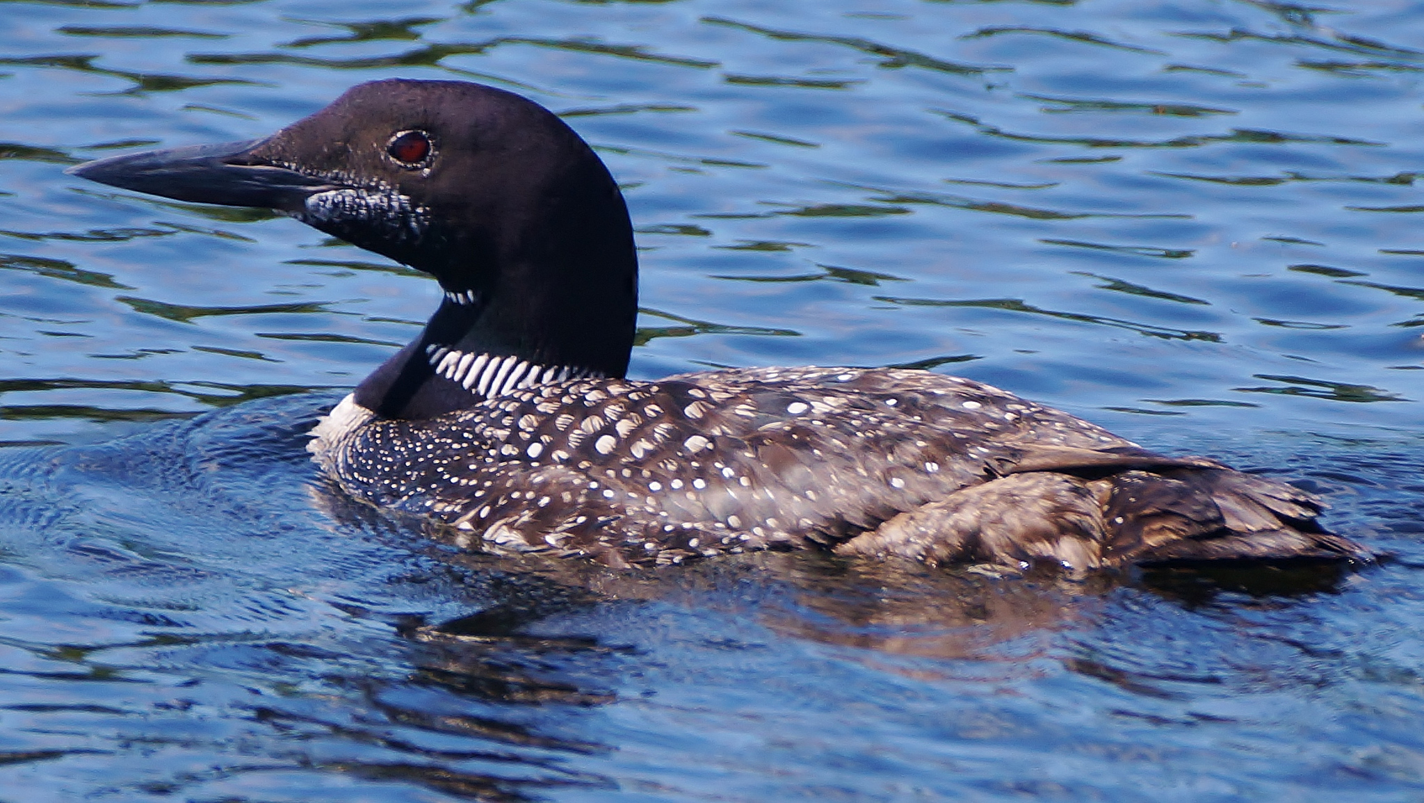
The Flowage, known for its high density of bald eagles, osprey, and common loons is also home to black terns, merlins, trumpeter swans, and over 150 other bird species. In addition, a variety of reptiles, amphibians and mammals, including deer, bear, bobcat, and timber wolves are found here. There have even been occasional sightings of moose.
Many opportunities exist to observe and enjoy wildlife in a remote and wild setting. Approach wildlife slowly and quietly and be particularly careful not to disturb nesting birds or animals with small young.
Auto & Motorcycle Tours
The Turtle-Flambeau Scenic Waters Area Auto Tour is a self guiding tour illustrating the interactions of humans with our native flora and fauna. This tour will give you a glimpse of the spectacular resources of the area. Management programs that will insure the future of these resources are explained. The tour is 24 miles long and has fifteen stops.
Turtle-Flambeau Scenic Waters Area Auto Tour booklets [PDF 3.4MB] are available at the Mercer Ranger Station and may also be found in the literature box on the kiosk at the Little Turtle Waterfowl Management Area parking lot – this site is the first stop on the tour.
A circle tour around the entire Turtle Flambeau Flowage is approximately 125 miles and will take you into the communities of Mercer, Springstead, Park Falls and Butternut. This scenic tour is especially nice in the fall when the trees in the forests are at their peak color. The leaves begin to change in September and typically peak around October 1st.